“I made my first transit map in grade five”: This teenage urban planning prodigy designed a fantasy map of the TTC
Transit wunderkind Jamie Kauri on why the Ontario Line is underrated, when the Eglinton LRT will start running and whether she’ll ditch public transit once she’s old enough to drive

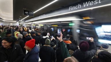
Last week, 15-year-old west-ender Jamie Kauri posted her fantasy transit map of the GTA to Twitter. Boasting a mix of actually planned and imaginary extensions, the rendering shows her vision for the TTC in 2070—a network spanning over 300 kilometres east to west and 140 kilometres north to south. The digital plans took Kauri more than 200 hours to create. Here, she weighs in on the future of public transit, her recommendations for Toronto’s city planners and why the Eglinton Crosstown LRT and the Ontario Line are worth the wait.
How does a tenth grader become a transit enthusiast? It comes naturally for me. I can remember picturing transit maps in my head when I was in grade one or two. When I was six, I started commuting from North York to downtown for school, and I still take transit for an hour each day, so I’ve been studying the routes without thinking about it for almost a decade. When I put it that way, it makes me feel old.
It’s one thing to know transit, but your fantasy map feels like a PhD thesis. When did you start working on it? I made my first transit map in grade five. After seeing the Line One extension into Vaughan, I tried to draw my own version of it on the side of a cardboard box. It was difficult to find one big enough, though, and tricky to write all the station names clearly. Then, four years ago, I made a Twitter account—to stay up to date on the Eglinton Crosstown construction—and followed fellow transit commentator August Puranauth, who creates digital maps on Inkscape, an open-source graphics editor. I taught myself how to use it and started this latest map in February of last year, working mostly on weekends. Overall, it probably took about 200 hours.
Related: Subway riders on the potential uses and abuses of TTC cell service

What was your favourite part of creating it? Designing new logos for the different lines was fun, and I liked giving each city a colour palette. I also tried to indicate some of the potential routes more clearly. The current TTC map is pretty good, but the GO train lines aren’t always there. It doesn’t show you that you can go all the way from Eglinton to Kitchener or how you can get to farther corners of the GTA, like Durham. Transit doesn’t end once you leave Toronto.
You’ve said your map is what the TTC could look like by 2070. Are you confident in your prediction? That year was just an estimate. A super distant date is kind of boring. You could predict anything you want for 200 years from now. On the flip side, 2050 is way too soon—building new stations can be very expensive. I should also say that parts of it are a dream scenario. I took it upon myself to axe Scarborough Centre station and turn it into a whole separate line. I don’t think that would happen in real life. The current plans call for an upgrade, not a complete overhaul.
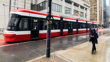
Of all the changes in your map—planned or invented—which would be the most exciting? Of the ones that aren’t currently planned, definitely the Midtown and North Toronto GO lines. They would speed up regional trips without forcing riders to go through Union, which is a common problem right now. The most exciting project that’s actually underway, in my opinion, is the Waterfront East LRT extension. It will let people more easily access all the new developments and parks on the eastern waterfront.

You clearly spend a lot of time thinking about transit. Are you satisfied with our current system? I’m more supportive of the TTC than most. I know some people are annoyed at projects that are taking a long time to complete, like the Eglinton Crosstown LRT, but it’ll be super helpful once its done. I think it’ll open by next spring at the very latest. I’m also a fan of the Ontario Line, which I know is contrary to popular opinion. People aren’t thrilled with the cost and wait times, but the convenience will be worth it. There’s also concern that the elevated part of the line will be noisy, but cities all over the world have subways that pop above ground. Maybe people picture the older systems in New York or Chicago, but this will be more modern and very quiet.
There have been rumblings about adding more ferry lines downtown. Do you think that’s a good idea? Ferries are an undervalued part of our transit system, and having them along the western waterfront could be great. I almost added a ferry line to my map, going from Long Branch to Etobicoke, but it may not be as useful there—we already have so many streetcars in the area. Adding ferries travelling to and from the Toronto Islands makes more sense.
What are the biggest problems planners need to tackle? Toronto used to have what many would consider one of the best bus systems in the world. After the recent service cuts, I’ve personally changed my mind on that. City planners have to realize that, when more buses circulate, more people will use them. Cutting services because fewer people are riding is the wrong approach. Safety is also a major problem—I have friends whose parents don’t let them take transit because of the recent attacks—and the TTC should consider solutions other than police. They could install barriers around the tracks and provide mental health supports, for example. And then there’s reliability: when service gets disrupted multiple times a day, it makes transit feel like a risky way to get around.
Are there any other cities you think Toronto should look to for inspiration? London, Paris, and Hong Kong have amazing transit, and China is the best at building quickly. Even in Canada, Montreal and Vancouver have impressive automated rail systems.
You’re turning 16 this year. Will you trade your Presto card for a driver’s licence? As a transit enthusiast, that’s kind of a moral dilemma! I’ll probably get my licence. That way, I can rent a car and drive out to places that the TTC doesn’t reach, like the Halton County railway museum. But, in general, I think cars cost a lot of money and shouldn’t have to be a necessity.
You still have two years of high school, but are you considering a career in urban planning? Yes. The first step is a university degree in urban studies, and then a job in the field. But that’s once I’m an adult, of course.
This interview has been edited for length and clarity.

Alex Cyr is a writer based in Liberty Village. He writes about health, fitness, people and culture. He also contributes to the Globe and Mail and Maclean’s and leads a YouTube channel for runners called Marathon Handbook.